The UN Endorsed the Equal Earth Projection: What the Resolution Actually Says
·5 min·View as Markdown
TagsEqual EarthMap ProjectionsWorld Map
Written byJordan Hale — Writer, Oh My Maps!
Contents
On Friday 4 September 2026, the United Nations General Assembly adopted resolution A/80/L.104, titled “Correct the map: rebalancing global cartographic representation and promoting equitable representation of the world’s regions, particularly Africa”. The vote was 164 in favour, 1 against, 6 abstentions. The single vote against came from the United States. Estonia, Georgia, Lithuania, Moldova, Serbia and Ukraine abstained.
Within hours the story was everywhere, and most of the headlines said some version of “the UN adopts a new world map”. That is not what happened. What actually happened is more interesting, and if you make maps for a living or for a classroom, the distinction matters.
What the resolution does
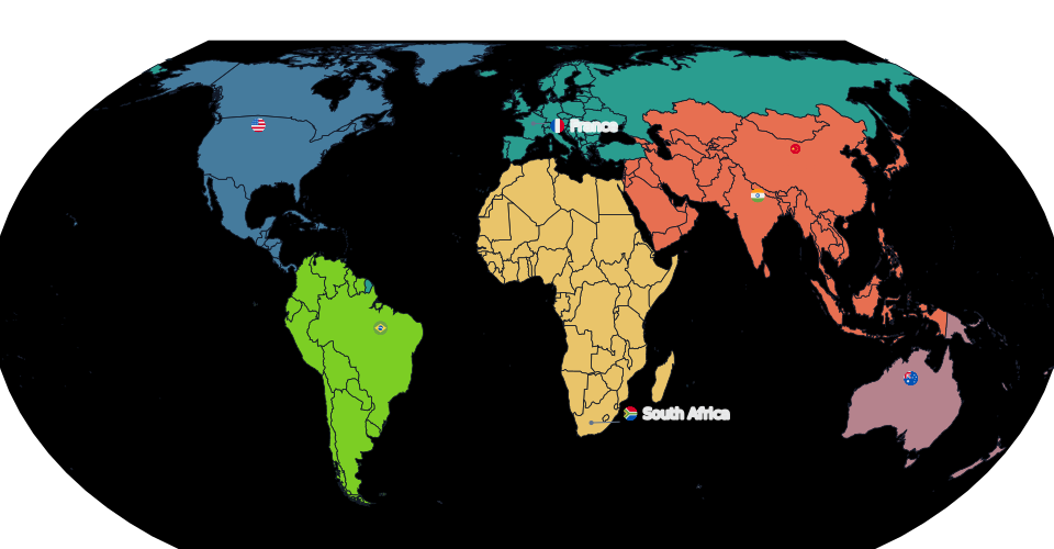
The text was tabled by Togo on behalf of the African Group, backed by the African Union and by the Correct the Map campaign that Africa No Filter and Speak Up Africa launched back in August 2025. Its operative language calls for wider use of equal-area map projections, and names the Equal Earth projection specifically, in the contexts where the relative size of continents actually carries meaning: education, media, and digital platforms.
That is the whole mechanism. It is a recommendation addressed to governments, schools, international organisations and technology companies.
What it does not do
Four things the resolution is not, each of which was reported as though it were:
It is not binding. General Assembly resolutions are recommendations under Article 10 of the UN Charter. No country, publisher or platform acquires a legal obligation from this text.
It does not ban Mercator. The resolution explicitly preserves Mercator for marine and air navigation, which is the job Mercator was invented to do and still does better than anything else.
It does not replace an official UN map, because there was never one to replace. The UN Geospatial Information Section states plainly that the Secretariat does not prescribe projections; its own maps have used Robinson, Winkel Tripel or Eckert IV, and none of those is equal-area. The UN emblem adopted in 1946 is an azimuthal equidistant projection and is unchanged.
It was not a technical decision. This was the General Assembly in political plenary, not UN GGIM or any cartographic body. The framing in the debate was about representation and what the resolution called cognitive justice, not about map algebra.
Read the primary sources
Three documents settle almost every question people are arguing about online:
- The UN Meetings Coverage record of the session, which carries the full title, the symbol A/80/L.104 and the roll call.
- UN News, which confirms the non-binding character and the list of audiences the text addresses.
- The European Union’s explanation of vote, which is the most precise document of the three. It states that the scope is strictly educational, that nothing in the text affects sovereignty or borders, and that the EU does not endorse any particular website or set of maps published under the Equal Earth name.
That last point went unreported almost everywhere, and it is a useful corrective to coverage that treated Equal Earth as though a specific product had been certified.
What is already changing
Within days of the vote, national institutions started moving, and the most instructive case is France.
The French foreign ministry dropped Mercator, but adopted Eckert IV, not Equal Earth. Eckert IV is also equal-area, so the decision satisfies the substance of the resolution while ignoring the specific projection named in it. That is the clearest evidence available that no global standard was created here. The resolution set a direction; institutions are choosing their own projection inside it.
Statistical agencies elsewhere have published Equal Earth world maps of their own in the same period, in several cases drawing on work that predates the vote. A recommendation with no force behind it moves when it lands on institutions that were already halfway there.
Why this is a real question and not a symbolic one
It would be easy to file this under gesture politics. It is worth resisting that, because the underlying complaint is arithmetic rather than opinion.
On a Mercator map, Greenland reads as roughly the size of Africa. Africa is about fourteen times larger. That is not an interpretation, and it is not a flaw in anyone’s perception. It is what the projection does, by design, in exchange for the property that makes it useful at sea. Every thematic map built on Mercator inherits that inflation, and a map coloured by a per-country value inherits it directly into the impression the reader walks away with.
The resolution’s argument is that most of the maps people actually look at, in schoolbooks and news graphics and map apps, are not navigation charts and have nothing to gain from that trade.
See it for yourself. Build a world map, then switch it between Mercator and Equal Earth. Your colours, labels and data survive the switch, so the only thing that changes is the argument the map makes.
Open the editorWhere to go next
This post is the factual spine. The four articles below take one thread each:
- What is the Equal Earth projection? covers where it came from, what it preserves, and what it gives up.
- The true size of Africa works through the distortion itself with the actual numbers.
- Equal-area vs compromise projections is the practical decision, because equal-area is not automatically the right answer for your map.
- How to make an Equal Earth map online is the hands-on version.
The short version
The UN did not change the world map. It voted, nearly unanimously, to recommend that when the size of places matters, you should use a projection that gets the size right. That recommendation carries no force, and it did not need to. Institutions started acting on it within days, and they did not all pick the same projection.
Ready to make yours? Oh My Maps! is free, runs in the browser and needs no sign-up. Your map is saved locally as you work, and exports carry no watermark.
Open the editor